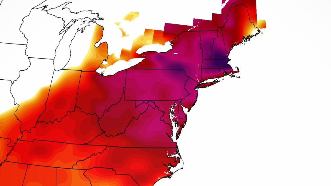
The NWS is forecasting Boston to have high temperatures of 96 degrees Sunday. The daily record high for that day is 93 degrees, while the monthly record for May is 97 degrees, set back on May 26, 1880.
Boston records are kept at Logan International Airport, which is right on the ocean, so those temperatures tend to be milder than the temperatures farther inland. And if the sea-breeze sets up in the right direction, it could prevent temperatures at the airport from reaching records.
In Worcester, Massachusetts, the daily record highs for Saturday and Sunday are 88 and 90 degrees respectively, but the forecast this weekend is set to crush those.
The forecast high on Saturday is 96 degrees, which not only breaks the daily record but also the monthly record of 94 degrees set back in 2010.
“We’re definitely a little bit ahead of schedule,” said Matthew Belk, Meteorologist at the NWS office in Boston said. “The average first 90-degree day in Boston is June 8. It’s a little bit earlier when you get out towards Hartford [Connecticut], May 30 is generally the average first 90 degree day.”
The early season heat wave this weekend is all thanks to a high pressure off the Eastern Seaboard resulting in southerly winds pushing hot and humid air across the Northeast bringing temperatures 20 to 30 degrees above normal for this time of year.
But it’s not just New England that will be dealing with extreme temperatures this weekend. Record high temperatures will also be felt down the I-95 corridor including New York, Washington, DC, Baltimore, and Philadelphia.
Half the population feeling the heat
Nearly 170 million people, roughly 52 percent of the US Lower 48 population, will feel 90-degree heat over the next few days.
“Over half of the US population will see temperatures at or above 90 degrees this weekend — and it’s only May,” said CNN’s Pedram Javaheri.
For some areas, it isn’t just the heat, but also the humidity that will bring “feels-like” temperatures into the triple digits.
Both Richmond, Virginia and Philadelphia are expecting a high temperature of 97 degrees Saturday, but thanks to the humidity it will feel more like 100.
In nearby Baltimore the 147th Preakness Stakes will be taking place. Thankfully the post time of 7:01pm will not be at the peak heat of the day, but it will still be plenty hot. Forecast temperature at the start of the race is 91 degrees.
“Saturday is forecast to be the hottest day of the weekend, with many locations reaching the mid-90s and heat indices approaching 100,” the NWS office in Baltimore/Washington said. “Since many outdoor events are planned this weekend in the region, be aware of the heat, and take extra precautions if you work or spend time outside this weekend.”
As if the heat wave wasn’t enough, the Mid-Atlantic and Northeast also have the potential for severe storms this weekend.
A cold front will produce isolated severe thunderstorms with both strong winds and hail as the main threats.
Heat is the number one killer
Even though the calendar may not show it is summer yet, Mother Nature has other plans, so it is important to be aware of the dangers with this heat wave. For example, do not ever leave children or animals in a hot car. Ever.
“Since this is going to be the first heat wave of the year, it’s important to be really cognizant of making sure that you’re aware of any heat illness or heat stroke related symptoms and being especially cautious of them and having extra water on hand to combat that and the importance of shade,” Aaron Swiggett, meteorologist at the NWS office in Raleigh.
Swiggett also points out that the forecast temperatures are actually for the shade, not in direct sunlight. So keep in mind your forecast high temperature is actually going to feel even hotter in the direct sun.
Skeen emphasizes it is important to take the heat seriously.
“Make sure you’re getting hydrated, staying in the shade, getting out of the sun when possible,” Skeen said. “And keeping an eye on folks in your life that are more susceptible to heat, such as young and the elderly and those that might be compromised.”
The good news is that this heat wave is short-lived. Once the cold front moves through the Eastern Seaboard on Monday, temperatures will drop back into the 60s and 70s for the Northeast and Mid-Atlantic.

