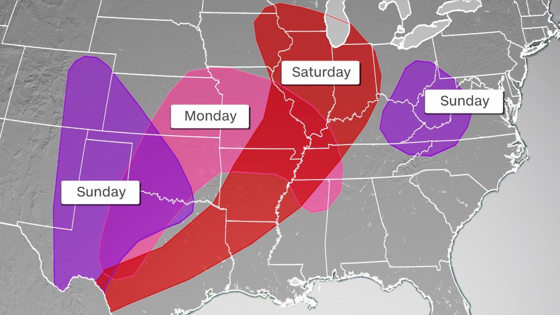
All severe weather hazards will be possible including damaging winds, hail, and tornadoes.
“Severe thunderstorms associated with a threat for wind damage and isolated large hail are possible on Saturday from the mid-Mississippi Valley northward into the western Great Lakes,” the Storm Prediction Center (SPC) said.
A level 2 out of 5 “slight” risk of severe storms has been issued and includes over 15 million people from Wisconsin to Arkansas, including Chicago and Indianapolis.
The best chance for severe storms to occur across this region will be in the afternoon and evening hours when the heating of the day has peaked.
While flooding may not be the primary concern with these storms, it is still something that needs to be monitored.
Widespread rainfall totals of 1 to 2 inches are forecast but some localized areas could see 3 to 4 inches of rain through the weekend.
“So while not currently expecting any major/widespread flooding to evolve, localized issues are a possibility,” the WPC said.
By Sunday, this first system will continue to shift east into the mid-Atlantic region.
Severe storms will be possible from western Pennsylvania down to the Virginia/Tennessee border in the latter half of the weekend. The primary threat will be damaging winds.
Double trouble for Texas
There will also be a new system moving through areas of Texas, New Mexico, Colorado, Kansas, and Oklahoma on Sunday, but before that system arrives, gusty winds will have already kicked up triggering an increased fire risk.
While rain would be welcomed, lightning, hail, and tornadoes are a different story.
“If we happen to get some lightning strikes in that area, that can actually start fires where the grasses are already dry where they may not get a whole lot of rain as the storms move to the east,” Aaron Ward, the science and operations officer at the NWS Amarillo office told CNN. “So that’s another thing we’re going to be watching for, possible fire starts due to the lightning on Sunday.”
A level 2 out of 5 “slight” risk for severe storms is in place for portions of the High Plains on Sunday and includes the cities of Lubbock, Amarillo, and Abilene in Texas.
These thunderstorms are likely to bring all modes of severe weather, including very large hail.
“The main concerns right now, what we’re looking at, is going to be large to very large hail, and damaging winds,” Ward said. “The hail could easily be golf ball to baseball size if everything comes together right.”
The timing for the storms will mainly be in the afternoon and early evening hours, though some storms will linger into the overnight time frame.
CNN’s Caitlin Kaiser and Haley Brink contributed to this report.