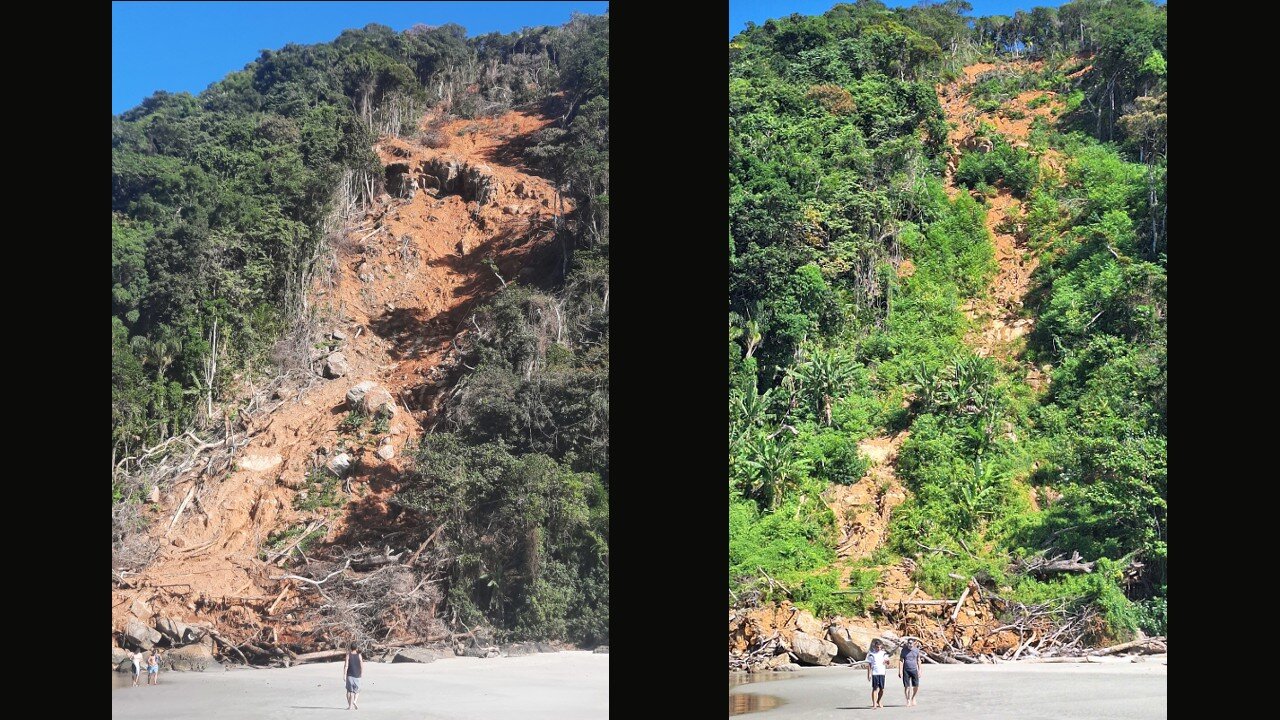

São Sebastião, a municipality on the coast of São Paulo state in Brazil that was partially cut off from the rest of the country in February 2023 after a period of torrential rain, had more than 1,000 landslide points, according to an inventory produced by researchers at the University of São Paulo’s Institute of Astronomy, Geophysics and Atmospheric Sciences (IAG-USP) and Institute of Geosciences (IGc-USP) using aerial images collected shortly after the disaster.
The inventory that mapped landslide risks in the municipality is published in the Brazilian Journal of Geology.
The scientists are now analyzing higher-resolution LIDAR images to find out how the inventory correlates with other variables and to develop a method for mapping the risk of landslides more precisely. LIDAR (Light Detection and Ranging) is an airborne remote sensing method that uses light in the form of a pulsed laser to generate precise 3D images of the Earth’s surface.
“In this type of analysis, known as a landslide susceptibility assessment, knowledge of the areas in which landslides occurred, including topographical, geological and other data, is extrapolated for other areas.
“We currently have digital elevation models with a spatial resolution [pixel size] of 30 m. The LIDAR data lets us go a step farther and apply elevation models with higher resolution [as high as 1 m] and more precision,” Carlos Henrique Grohmann, full professor at IAG-USP, told Agência FAPESP.
Grohmann is the leader of the project and involves a partnership with the São Paulo State Institute of Geography and Cartography (IGC-SP, an arm of the Department of Budget and Administration). The institute is creating a repository of LIDAR images for the entire state. This is the first time the scientific community has had access to LIDAR data for the Serra do Mar region.
The expectation is that the new methodology will be ready by the end of 2025, so that policymakers and planners can use it to map landslide-prone areas in the municipality more comprehensively.
In February 2023, São Sebastião declared a state of emergency due to the damage caused by a record amount of rain totaling 683 millimeters (mm) in less than 15 hours—the monthly average is 300 mm. At least 60 people died and hundreds were made homeless, not to mention the destroyed infrastructure and other material damage. Roads were swept away or blocked, hindering travel and transportation.
“What happened in São Sebastião last year was an anomaly, but heavy rainfall is usual in summer, and landslides are frequent. The point is that areas once covered with vegetation have lost this protection and are now highly vulnerable,” Grohmann said.
Scientific studies have shown that extreme weather events such as severe drought, torrential rain and tropical cyclones will be increasingly frequent and intense from now on because of global warming. According to the Climate Change 2023 Synthesis Report produced by the Intergovernmental Panel on Climate Change (IPCC), the global surface temperature is already 1.1 °C higher than in the preindustrial period (1850–1900) and is set to reach 1.5 °C above that level by 2035.
Last year was the warmest in the planet’s history, according to the World Meteorological Organization (WMO). This new reality calls for prevention and planning actions based on up-to-date information.
São Sebastião, which has an area of 402 square kilometers and some 81,000 inhabitants, had around 2,200 houses in 21 landslide-prone areas in 2018, according to a survey published by the Technological Research Institute (IPT, an arm of the São Paulo State Department of Economic Development). The city entered into an agreement with IPT in February 2024 to update this map of high-risk areas following the 2023 disaster.
IPT’s 2024 report lists neighborhoods such as Barra do Una, Juquehy, Barra do Sahy, Baleia, Camburi, Boiçucanga and Itatinga as high-risk. All were badly damaged by heavy rain in February 2023.
New tools
Landslides are common geological processes in mountainous areas, especially those with a tropical climate like Serra do Mar, where São Sebastião is located. They may occur on various spatial and temporal scales and are among the main agents of erosion that cause geomorphic change on cliffs, escarpments and hillsides.
In light of their destructive effects, especially in irregularly occupied areas such as squatter settlements, landslides are a focus for scientific studies aiming at identification, characterization, monitoring and prevention.
“Other government bodies are analyzing high-risk areas. We also plan to compare the data collected in our survey with the findings of these official studies,” Grohmann said.
His group uses drone images and 3D modeling, as well as LIDAR, which determines the height of objects by measuring the time taken by pulses to return to the airborne device. The 3D results display the shape of the terrain and specific surface features, characterizing the structure of the vegetation and the topography of the bare ground without the influence of forests or buildings.
In addition to predicting landslides in São Sebastião, the group expects to obtain a morphometric characterization and assessment of surface changes in the Toque-Toque Grande neighborhood, which has been monitored since 2010, as well as points in Morro da Baleia and Sahy.
More information:
Rebeca Durço Coelho et al, Landslides of the 2023 summer event of São Sebastião, southeastern Brazil: spatial dataset, Brazilian Journal of Geology (2024). DOI: 10.1590/2317-4889202420240006
Citation:
Researchers use high-resolution images to create model that predicts landslide risk in coastal areas (2024, November 13)
retrieved 13 November 2024
from https://phys.org/news/2024-11-high-resolution-images-landslide-coastal.html
This document is subject to copyright. Apart from any fair dealing for the purpose of private study or research, no
part may be reproduced without the written permission. The content is provided for information purposes only.

