
Astronaut photos reveal the dramatic transformation of Madagascar’s largest estuary, the Betsiboka, over decades. Deforestation and agriculture have caused severe erosion, changing the delta’s landscape, forming new islands, and expanding mangroves significantly since 1984.
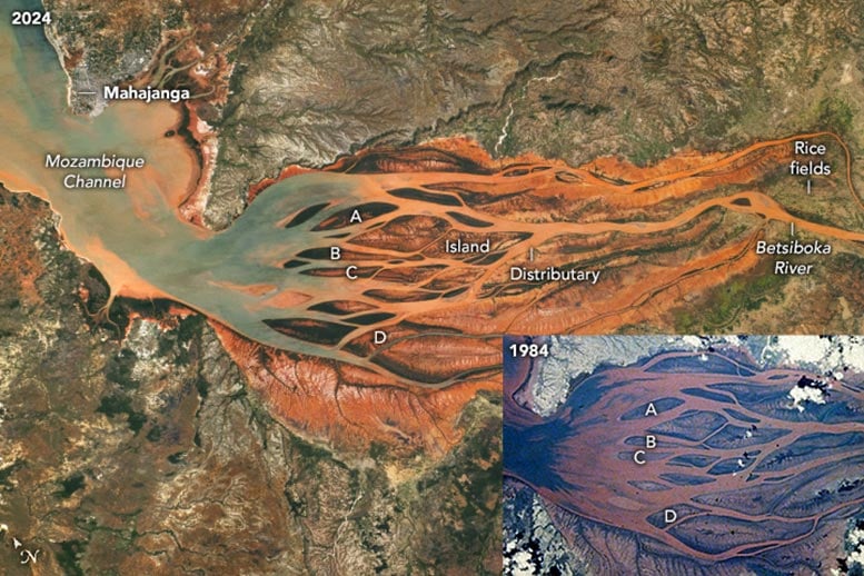
An astronaut aboard the International Space Station (ISS) captured this image of Madagascar’s largest estuary. Today, more than half of the estuary is filled by the growing delta of the Betsiboka River, which flows northwest toward the Mozambique Channel. The port city of Mahajanga is located along the coast in the top left of the image. Rice is the primary crop cultivated in and around the delta region.
In the past 50 years, large areas of forest have been cleared for logging and the expansion of agricultural land to accommodate Madagascar’s rapidly increasing population. This deforestation has caused significant soil erosion from the hillsides within the Betsiboka watershed and other regions across the Madagascar. The eroded soil is carried into the Betsiboka River and transported downstream. After decades of accelerated erosion, the delta has expanded to about 35 kilometers (22 miles) in length, filling much of the estuary, which was navigable by ships less than a century ago.
Dynamic Delta Development
The delta, centered in this image, is a network of distributary channels between larger and smaller “tear-drop” islands. The iron-rich soils color the water in the distributaries a red-orange hue. Several islands appear dark green where forests have colonized the newly deposited land. Today, the delta and neighboring shorelines are home to the largest area of mangrove forests in Madagascar.
Comparison and Changes Over Time
Compared with an astronaut photo taken 40 years ago (1984 inset), the 2024 photograph illustrates how the delta has continued to grow towards the Mozambique Channel. Sand banks that were covered by water at high tide have expanded and grown upward to become vegetated islands. Since 1984, two new vegetated islands have formed on either side of island “A,” one downstream of islands “B” and “C,” and three downstream of island “D.” A yet unvegetated sand bar is also visible downstream of island “D.”
Astronaut photograph ISS071-E-111691 was acquired on May 23, 2024, with a Nikon Z9 digital camera using a focal length of 210 millimeters. It is provided by the ISS Crew Earth Observations Facility and the Earth Science and Remote Sensing Unit, Johnson Space Center. The image was taken by a member of the Expedition 71 crew. The image has been cropped and enhanced to improve contrast, and lens artifacts have been removed. The International Space Station Program supports the laboratory as part of the ISS National Lab to help astronauts take pictures of Earth that will be of the greatest value to scientists and the public, and to make those images freely available on the Internet.