
In a massive research project spanning five years and stretching the length of the Northeast seaboard, a Wellesley College professor is examining how various fishing communities can change their fishing habits in order to adapt to climate change.
Rebecca Selden, an assistant professor of biological sciences at Wellesley, is creating a “spatial sea map” designed to illustrate the adaptive styles of 266 fishing communities stretching across the East Coast from North Carolina to Maine. Her research, conducted with colleagues from four other institutions, was published on October 15 in ICES Journal of Marine Science.
Selden’s project is one of the first to provide detailed, high-resolution information about how individual communities could change their fishing patterns in response to climate change. Such community-level information is critical to understand which communities might be most vulnerable or resilient to changes in the distribution of species that they fish.
Climate change is changing the seascape in many ways, Selden notes. The water is changing—becoming more acidified, for example. Species are relocating in order to adapt to changing water temperatures. And the ocean is being used in new and different ways—for ocean-based wind turbines, for example.
“These changes can challenge fishing communities that rely on marine resources,” Selden says. “Many communities have diversified what they catch, or where they fish, to cope with changes in where fish are found.”
But too often, we don’t understand how specific communities are adapting. “We need to understand what works in different locations,” Selden notes.
In order to better understand how individual communities are adapting, Selden helped develop a Communities at Sea (CaS) database that links historical fishing patterns at sea to port communities. This allows researchers and policy makers to quantitatively evaluate catch flexibility, catch switching, and fishing ground mobility of fishing communities in the Northeast U.S.
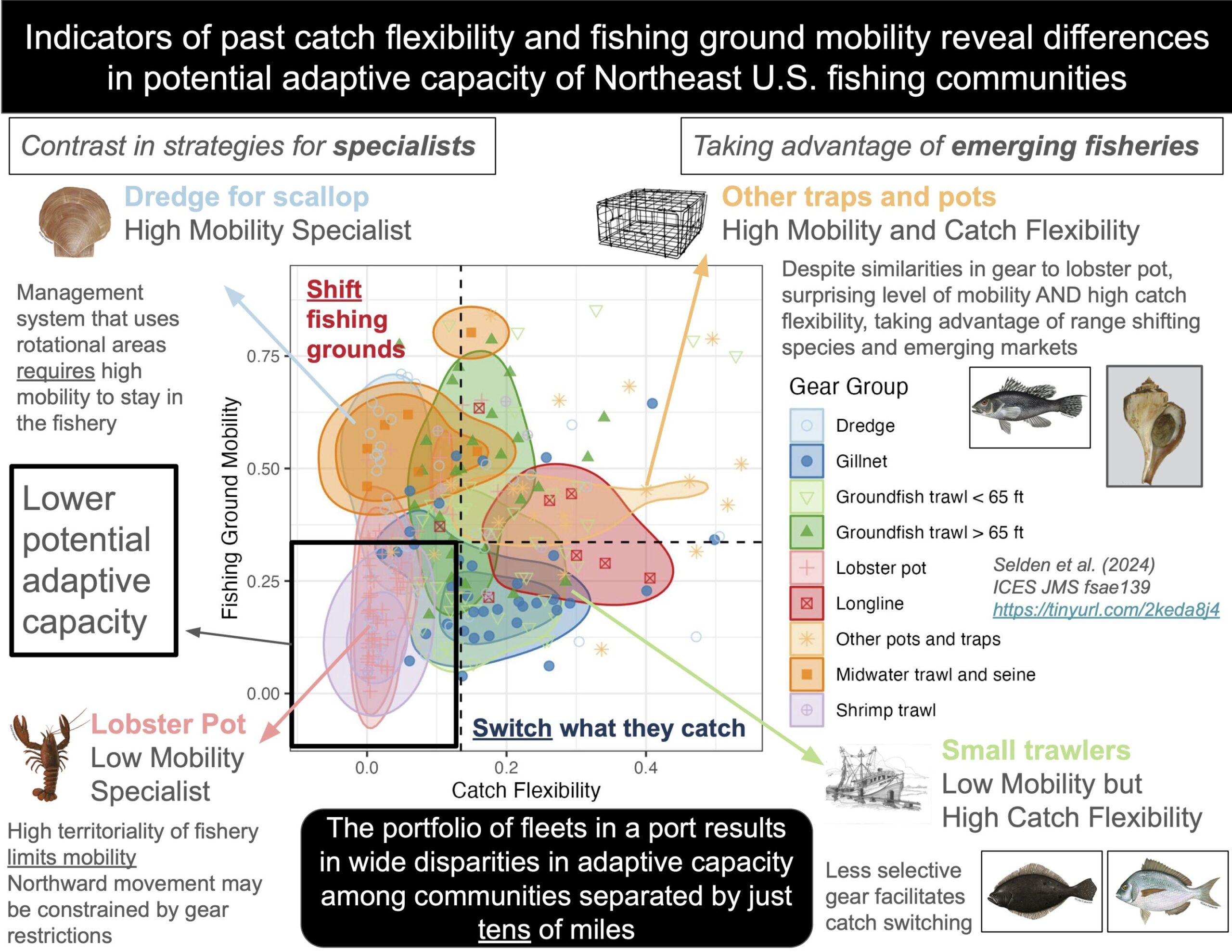
Her analysis shows that different communities, and different gear types, are adapting in different ways to changes in the seascape. For example, dredge fleets that specialize on scallop are highly mobile, which bodes well for being able to follow scallop as they move north or deeper.
Trawl fleets, on the other hand, are more likely to maintain their traditional fishing locations, but change what they’re fishing for. Lobster trap communities in the Gulf of Maine maintained a focus on both their traditional fishing location and their traditional catch. Meanwhile, Southern New England trap fleets dealing with declines in lobster populations have shown surprising levels of catch flexibility, focusing less on lobster and more on emerging fisheries like Jonah crab and whelk.
As a result, ports that are only separated by tens of miles can have dramatically different capacities for change—and dramatically different methods of change—based on the portfolio of fleets that land there.
The resulting “spatial seascape” that Selden has created yields important community-level information that is critical to identifying which fishing communities are least able to change what they catch and where they fish. This information will help prioritize efforts to reduce barriers to diversification, develop new markets, and create policies to allow fishermen to successfully adapt to changing ocean conditions, Selden notes.
“Fishermen are not adverse to adaptation,” Selden says. “The challenges [with adaptation] tend to be associated with regulations and policies, not fishermen or fishing communities themselves.”
Some of the communities in Selden’s study are small and perhaps relatively unfamiliar—like Harwichport, Massachusetts, with less than five vessels in each of the two fleets that currently land there. Other communities in the study are larger and more well known, including New Bedford, Massachusetts, the nation’s top port in terms of total fishery revenue for the last 20 years
One goal of Selden’s research is to draw attention to some of the smaller communities, which might otherwise be less likely to be positively affected by new policies, Selden says.
Going forward, Selden is currently working to compare the adaptive capacity of fishing communities on the U.S. East and West Coasts through collaboration with natural and social scientists at NOAA’s Northwest Fisheries Science Center.
And Selden’s big hope is that her research can help influence policy decisions. “So many fishermen have an immense capacity for change, ” she says. “It’s often regulations that are the limiting factor. By creating a complete marine spatial map of the lower 48 states, we can help people make better decisions at the local, regional and international levels.”
More information:
Rebecca L Selden et al, Using historical catch flexibility and fishing ground mobility as measures of the adaptive capacity of fishing communities to future ocean change, ICES Journal of Marine Science (2024). DOI: 10.1093/icesjms/fsae139
Provided by
Wellesley College
Citation:
New research visualizes how fishing communities can change fishing habits to adapt to climate change (2024, October 21)
retrieved 21 October 2024
from https://phys.org/news/2024-10-visualizes-fishing-communities-habits-climate.html
This document is subject to copyright. Apart from any fair dealing for the purpose of private study or research, no
part may be reproduced without the written permission. The content is provided for information purposes only.