Arctic and Antarctic regions faced significant ice losses in 2024, with Arctic sea ice reaching its seventh-lowest extent on record. The persistent reduction in polar ice contributes to broader ecological changes and heightened warming, driven by the ice-albedo feedback mechanism.
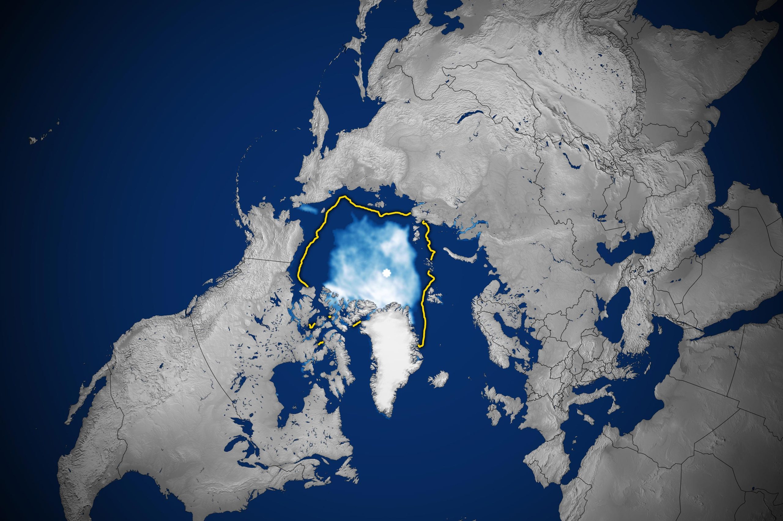
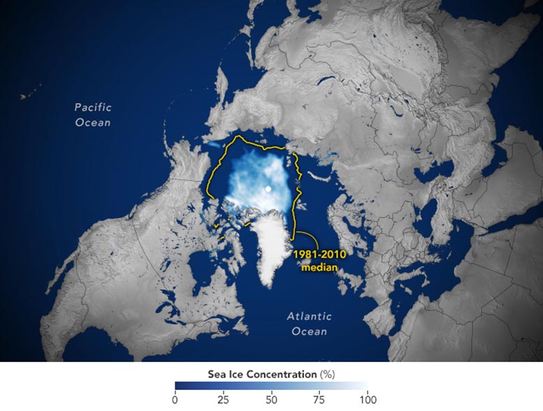
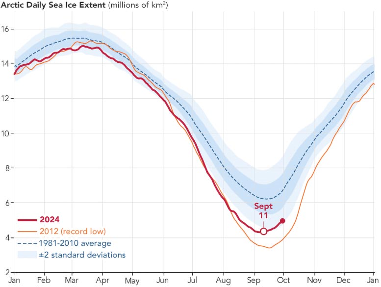
Arctic sea ice retreated to near-historic lows in the Northern Hemisphere this summer, melting to its likely minimum extent for the year on September 11, 2024. This observation comes from NASA and the National Snow and Ice Data Center (NSIDC), highlighting a continuing trend of diminishing ice cover in the Arctic Ocean that has persisted for decades.
Throughout the year, the Arctic sea ice naturally expands and contracts in response to seasonal variations. Researchers monitor these changes to understand the Arctic’s long-term reactions to increasing air and sea temperatures and prolonged melting seasons. Data collected over the past 46 years from satellites show a consistent pattern: more extensive melting during the summer months and reduced ice formation during the winter.
Impacts of Diminishing Arctic Ice
Tracking sea ice changes in real-time has revealed wide-ranging impacts, from losses and changes in polar wildlife habitat to impacts on local communities in the Arctic and international trade routes.
This year, Arctic sea ice shrank to a minimum extent of 4.28 million square kilometers (1.65 million square miles), as shown on the map above. That’s about 1.94 million square kilometers (750,000 square miles) below the 1981 to 2010 end-of-summer average of 6.22 million square kilometers (2.4 million square miles). The difference in ice cover spans an area larger than the state of Alaska. Sea ice extent is defined as the total area of the ocean with at least 15 percent ice concentration.
Trends and Measurements of Sea Ice
This year’s minimum—the seventh lowest in the satellite record—remained above the all-time low of 3.39 million square kilometers (1.31 million square miles) set in September 2012. While sea ice coverage can fluctuate from year to year, it has trended downward since the start of the satellite record for ice in the late 1970s. Since then, the loss of sea ice has been about 77,800 square kilometers (30,000 square miles) per year, according to NSIDC.
Scientists currently measure sea ice extent using data from passive microwave sensors aboard satellites in the Defense Meteorological Satellite Program, with additional historical data from the Nimbus-7 satellite, jointly operated by NASA and the National Oceanic and Atmospheric Administration (NOAA).
Sea ice is not only shrinking, it’s also getting younger, noted Nathan Kurtz, chief of the Cryospheric Sciences Laboratory at NASA’s Goddard Space Flight Center. “Today, the overwhelming majority of ice in the Arctic Ocean is thinner, first-year ice, which is less able to survive the warmer months. There is far, far less ice that is three years or older now,” Kurtz said.
Ice thickness measurements collected with spaceborne altimeters, including NASA’s ICESat and ICESat-2 satellites, have found that much of the oldest, thickest ice has already been lost. New research out of NASA’s Jet Propulsion Laboratory shows that in the central Arctic, away from the coasts, fall sea ice now hovers around 1.3 meters (4.2 feet) thick, down from a peak of 2.7 meters (8.8 feet) in 1980.
The State of Ice in the Southern Hemisphere
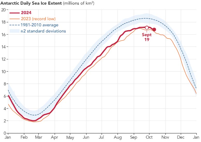
Sea ice in the southern polar regions of the planet was also low in 2024. Around Antarctica, scientists tracked near-record-low sea ice at a time when it should have been growing extensively during the Southern Hemisphere’s darkest and coldest months.
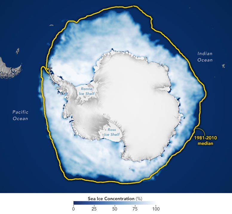
Ice around the continent likely reached its maximum extent for the year on September 19, 2024, when growth stalled out at 17.16 million square kilometers (6.63 million square miles). This year’s maximum, shown on the map above, was the second lowest in the satellite record and remained above the record winter low of 16.96 million square kilometers (6.55 million square miles) set in September 2023. The average maximum extent between 1981 and 2010 was 18.71 million square kilometers (7.22 million square miles).
The meager growth in 2024 prolongs a recent downward trend. Prior to 2014, sea ice in the Antarctic was increasing slightly by about 1 percent per decade. Following a spike in 2014, ice growth has fallen dramatically. Scientists are working to understand the cause of this reversal. The recurring loss hints at a long-term shift in conditions in the Southern Ocean, likely resulting from global climate change.
“While changes in sea ice have been dramatic in the Arctic over several decades, Antarctic sea ice was relatively stable. But that has changed,” said Walt Meier, a sea ice scientist at NSIDC. “It appears that global warming has come to the Southern Ocean.”
In both the Arctic and Antarctic, ice loss compounds ice loss. This is because while bright sea ice reflects most of the Sun’s energy back to space, open ocean water absorbs 90 percent of it. With more of the ocean exposed to sunlight, water temperatures rise, further delaying sea ice growth. This cycle of reinforced warming is called ice-albedo feedback.
Overall, the loss of sea ice increases heat in the Arctic, where temperatures have risen about four times the global average, Kurtz said.
NASA Earth Observatory images by Lauren Dauphin, using data from the National Snow and Ice Data Center. Story by Sally Younger, NASA’s Earth Science News Team, updated and adapted for Earth Observatory by Kathryn Hansen.