
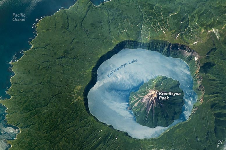
An astronaut captured an enthralling image of Onekotan Island from the International Space Station, showcasing the Krenitsyna Volcano of the Kuril Islands chain.
This remarkable photo highlights geographical features like the Tsar-Rusyr caldera and its deep, reflective Kol’tsevoye Lake, which is among Russia’s deepest. The volcano’s last eruption in 1952 adds a historical layer to the viewing experience, juxtaposing the rugged terrain against the caldera’s lush, vegetated landscape.
Capturing Onekotan: A Stunning Image From Space
An astronaut aboard the International Space Station (ISS) captured this photo of Onekotan Island while orbiting over the northwest Pacific Ocean. It is part of the Kuril Islands, an archipelago extending between the Kamchatka Peninsula in Russia and Hokkaido in Japan. The image prominently features Krenitsyna Volcano, located on the island’s southern side.
The photo, taken at a low-oblique angle, highlights the island’s rugged terrain, including cliffs, coastlines, and mountain formations. To avoid an optical illusion known as relief inversion, the image has been rotated so that north appears at the bottom.
The Tsar-Rusyr Caldera: A Volcanic Wonder
The Tsar-Rusyr caldera, a large, crater-like depression formed by ground collapse into a partially emptied magma chamber after an eruption, is clearly visible. Steep 300-meter (1,000-foot) cliffs surround the caldera, casting long shadows along the volcano’s eastern interior.
The caldera holds the blue waters of Kol’tsevoye Lake, which contrasts with the surrounding vegetated summer landscape. Reaching depths of up to 370 meters (1,200 feet), the lake is one of the deepest in Russia. Its surface reflects sunlight back to the camera, producing sunglint, and it also mirrors the clouds drifting above the central peak.
Volcanic Majesty: Krenitsyna Peak
Situated at the center of the caldera is Krenitsyna Peak, which stands approximately 1,300 meters (4,200 feet) above sea level. The slopes of this stratovolcanic peak consist of dark-colored valleys and ridges, caused by volcanic flows and erosive processes, that reach the surface of Kol’tsevoye Lake. The last eruption of this complex occurred in November 1952 and was categorized as “moderate,” with a Volcanic Explosivity Index (VEI) of 3.
West of the caldera, a mountain system is visible on the right side of the image. This rugged terrain contrasts with the opposite side of the caldera, where the landscape flattens out as it reaches the Pacific Ocean. Small patches of bright snow and ice remain in the valleys between the mountain and the coastline.
Astronaut photograph ISS069-E-71110 was acquired on August 19, 2023, with a Nikon D5 digital camera using a focal length of 1,150 millimeters. It is provided by the ISS Crew Earth Observations Facility and the Earth Science and Remote Sensing Unit, Johnson Space Center. The image was taken by a member of the Expedition 69 crew. The image has been cropped and enhanced to improve contrast, and lens artifacts have been removed. The International Space Station Program supports the laboratory as part of the ISS National Lab to help astronauts take pictures of Earth that will be of the greatest value to scientists and the public, and to make those images freely available on the Internet.