
Detailed images of the 66-million-year-old Nadir Crater offer new insights into catastrophic asteroid impacts, showing extensive damage and geological changes including a huge tsunami.
Researchers at Heriot-Watt University have released new images of the Nadir Crater, a 9 km (~5.5 mile) wide asteroid impact crater located 300m (~1000 feet) under the floor of the Atlantic Ocean. These new images confirm the Nadir Crater was caused by an asteroid smashing into Earth at the end of the Cretaceous period approximately 66 million years ago. This is the same age as the 200 km (~125 mile) wide, Chicxulub impact crater in Mexico, which is associated with the extinction of dinosaurs.
The images have helped the researchers determine what happened in the minutes following impact: the formation of an initial bowl-shaped crater, rocks turned to a fluid-like state and flowing upwards to the crater floor, the creation of a damage zone covering thousands of square kilometers beyond the crater, and an 800-meter-plus (2,600-foot-plus) high tsunami that would have traveled across the Atlantic ocean.
The findings are reported in Nature Communications Earth & Environment.
Unveiling Ancient Impacts
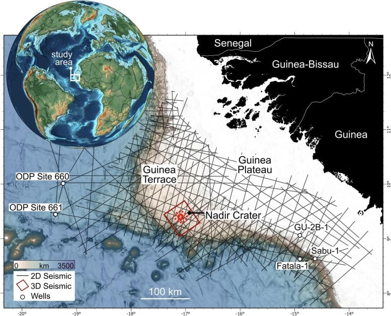
The Nadir Crater was discovered in 2022 by Dr. Uisdean Nicholson of Heriot-Watt University when he was studying seismic reflection data of the Atlantic Ocean’s seabed, off the coast of Guinea in West Africa. The data revealed a depression over 8.5km wide, which Dr. Nicholson suspected could be an asteroid impact crater.
He worked with planetary scientists and geologists in the UK and the USA to classify the crater: the data suggested it was from an asteroid hundreds of meters wide hitting the planet around 66 million years ago. However, they couldn’t definitively state that, until now.

From a Grainy Ultrasound to a 3D Image
High-resolution, 3D seismic data was captured by TGS, a global geophysical company, and shared with Dr. Nicholson, a geologist. The data proves that an asteroid caused the Nadir Crater.
Dr. Nicholson said: “There are around 20 confirmed marine craters worldwide, and none of them has been captured in anything close to this level of detail. It’s exquisite.
“Craters on the surface are usually heavily eroded and we can only see what is exposed, whereas craters on other planetary bodies usually only show the surface expression.
“These data allow us to image this fully in three dimensions and peel back the layers of sedimentary rock to look at the crater at all levels.
“One way to understand it is to think about a pregnancy ultrasound. A few generations ago, the ultrasound would show a grainy blob. Now you can see the baby’s features in 3D, in incredible detail — including all the internal organs.
“We’ve gone from 2D, fuzzy imaging to amazing high-resolution imaging of the Nadir Crater.”

Impact Dynamics and Consequences
Dr. Nicholson said: “The new images paint a picture of the catastrophic event.
“We originally thought the asteroid would have been around 400m wide. We now think it was 450-500m wide, because of the larger crater size as shown by the 3D data.
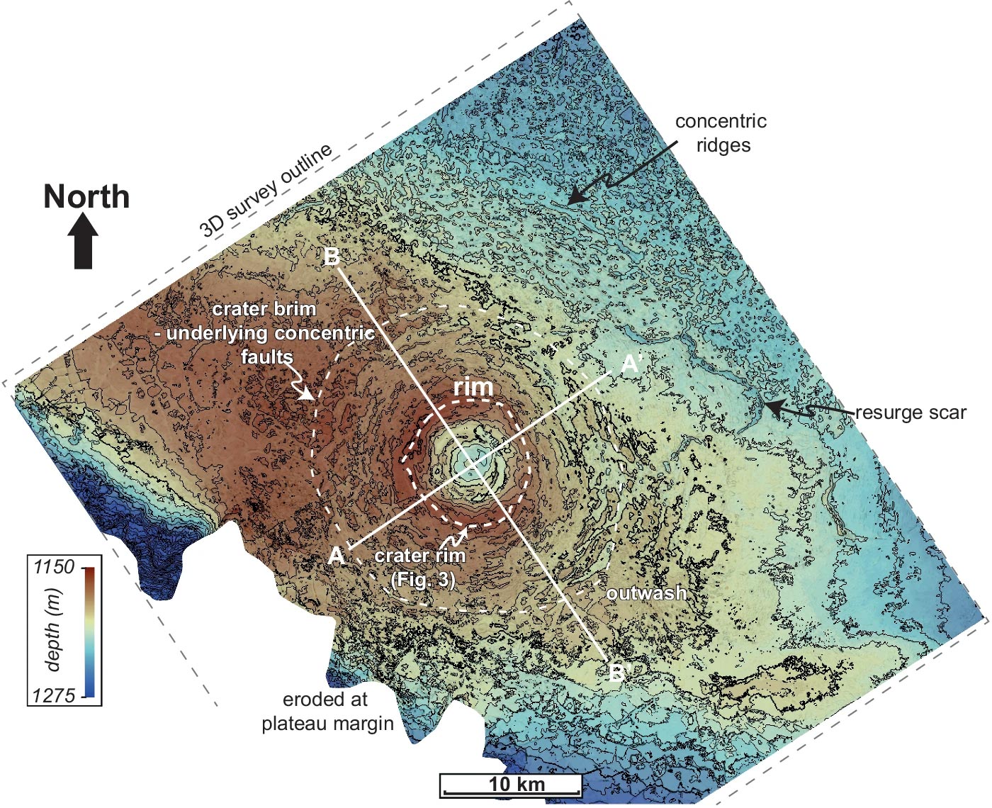
“We can tell it came from about 20-40 degrees to the northeast, because of spiralling thrust-generated ridges surrounding the crater’s central peak — those are only formed following a low-angle oblique impact.
“And we think it would have hit Earth at about 20 km per second, or 72,000 km per hour, although we still need to confirm this with a new set of impact models.”
Using the data, the scientists created a timeline of what happened in the seconds and minutes after impact.
Dr. Nicholson said: “After the impact and the central uplift forming, the soft sediments surrounding the crater flowed inwards towards the evacuated crater floor, creating a visible ‘brim’.
“The earthquake shaking caused by the impact appears to have liquefied the sediments below the seabed across the entire plateau, causing faults to form below the seabed.
“The impact was also associated with large landslides as the plateau margin collapsed below the ocean.
“As well as this, we see evidence for a train of tsunami waves going away from, then back towards the crater, with large resurge scars preserving evidence of this catastrophic event.”
Exploring the Nadir Crater: A Unique Opportunity
Dr. Nicholson points out that humans have never witnessed an asteroid of this size crashing into Earth.
“The closest humans have come to seeing something like this is the 1908 Tunguska event, when a 50-metre asteroid entered Earth’s atmosphere and exploded in the skies above Siberia.”
“The new 3D seismic data across the whole Nadir Crater is an unprecedented opportunity to test impact crater hypotheses, develop new models of crater formation in the marine environment and understand the consequences of such an event.
“We’ve applied to IODP3, which is a new international drilling program, to drill into the seabed and recover cores from the crater. These will give us more information about the shock pressures experienced during impact, and the precise age and sequence of events that occurred after this event.”
Unlike the Moon, Earth’s Craters Erode
Collaborator Dr. Sean Gulick of the University of Texas at Austin, USA, a geophysicist and expert on impact processes, noted: “3D seismic images of a fully-preserved impact crater are a fantastic research opportunity that can allow us to consider how impact processes and craters scale with the size of the impactor both for understand the evolution of the Earth, and other worlds.”
Collaborator Dr. Veronica Bray of the University of Arizona, an expert in impact cratering across the solar system, commented: “We see pristine impact craters on airless bodies like the Moon, but don’t have subsurface structural information.
“On the Earth, that is reversed: we have structural data from seismics, field mapping and drill cores, but the craters are usually very eroded at the surface.
“The new 3D seismic imaging of Nadir gives us both. It’s a startlingly good look at an impact crater!”
Assessing Asteroid Threats
The rubble pile asteroid Bennu is around 400m in diameter. It is considered the most hazardous object in near-Earth orbit. According to NASA scientists, its total impact probability through the year 2300 is about 1 in 1,750 (or 0.057%). The researchers were also able to identify 24 September 2182 as the most significant single date in terms of a potential impact, with an impact probability of 1 in 2,700 (or about 0.037%).
DOI: 10.1038/s43247-024-01700-4