
Stay informed with free updates
Simply sign up to the Climate change myFT Digest — delivered directly to your inbox.
Rising global temperatures helped drive “extreme rainfall events” around the world in September, with some areas experiencing months’ worth of rain in just a few days, the Copernicus earth observation agency said.
Europe was hit by “extreme precipitation” while the south-east US has suffered powerful storms in quick succession, leaving communities scrambling to prepare and evacuate.
Hurricane Milton is expected to bring heavy rainfall and storm surges this week to areas of Florida still recovering from hurricanes Helene and Debby. Hurricane Helene caused flooding and mudslides across several southern US states less than two weeks ago, killing more than 225 people.
Storm Boris brought incessant rainfall to central and eastern Europe for several days last month, generating deadly floods that affected Poland, the Czech Republic, Slovakia and Austria particularly badly.
“The risk of extreme rainfall will continue to increase with rising temperatures,” said Samantha Burgess, deputy director of the Copernicus Climate Change Service. “The sooner we reach net zero emissions, the sooner we can mitigate this risk.”
A “warmer atmosphere” had made the rainfall “worse”, Burgess said. Hotter air holds more moisture, causing more water to evaporate from the surface of the ocean.
This resulted in clouds with a greater number of large rain droplets, according to the UK Met Office.
Conditions were also wetter than average over northern Africa, eastern China and north-western Australia, Copernicus said. Taiwan and the Philippines have been hit by Typhoon Krathon in recent days, and Pakistan has been “heavily affected” by its annual monsoon rains, that run from July to September.
At the same time wildfires burnt in parts of Russia and South America.
The world was still on track to set a heat record for 2024, with unusually high temperatures so far this year making it “almost certain” that this year would be the warmest yet, Copernicus said.
September was the second-warmest month on record over land and sea, with the average global temperature on land 1.54C above the 1850 to 1900 pre-industrial level. A temporary rise of 1.5C in the average global temperature is distinct from the Paris Agreement goal of limiting long-term global warming to 1.5C.
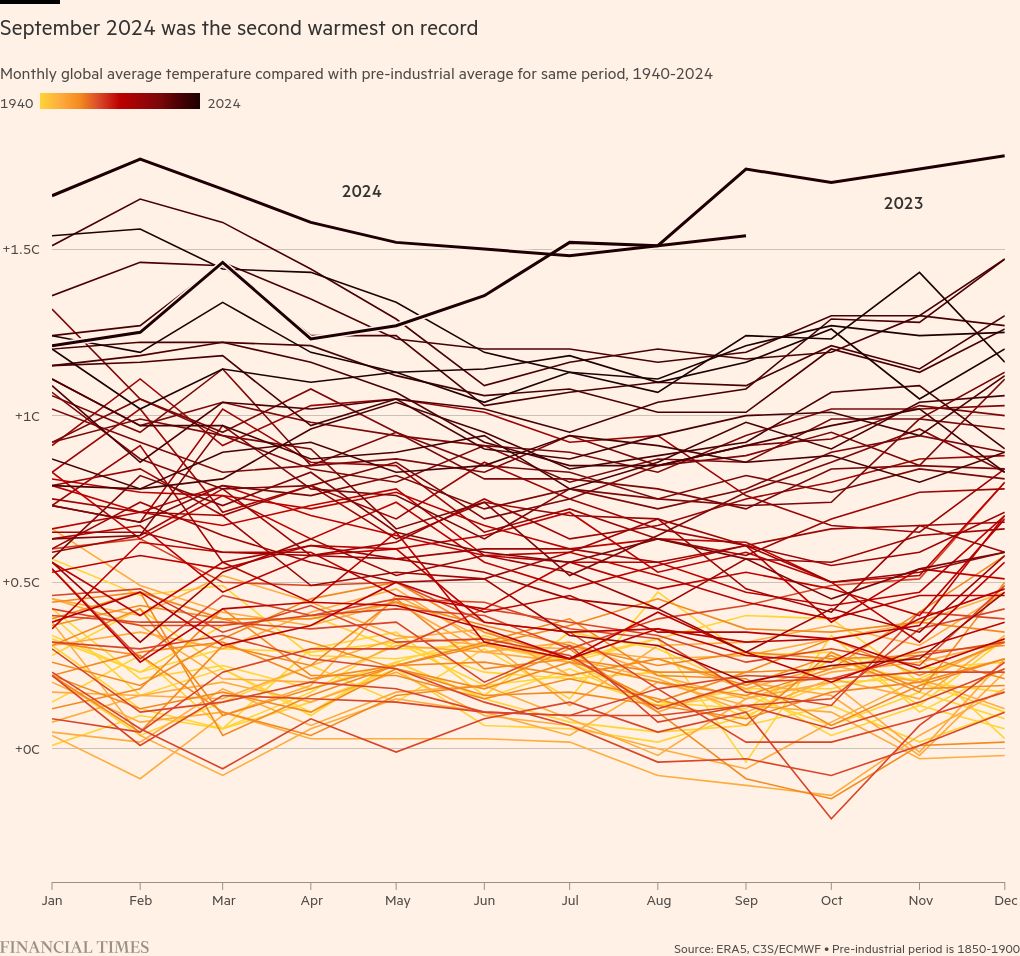
The average sea surface temperature was 20.83C in September, even as the naturally occurring La Niña weather phenomenon led to below-average temperatures in parts of the Pacific. La Niña is linked to a cyclical cooling of sea and surface temperatures. Arctic and Antarctic sea ice cover are both at historically low levels.
Rivers around the world were at their driest level in more than three decades last year, the World Meteorological Organization said on Monday. Its secretary-general Celeste Saulo said water was “the canary in the coal mine of climate change”.
“As a result of rising temperatures, the hydrological cycle has accelerated. It has also become more erratic and unpredictable, and we are facing growing problems of either too much or too little water.”
Climate Capital
Where climate change meets business, markets and politics. Explore the FT’s coverage here.
Are you curious about the FT’s environmental sustainability commitments? Find out more about our science-based targets here