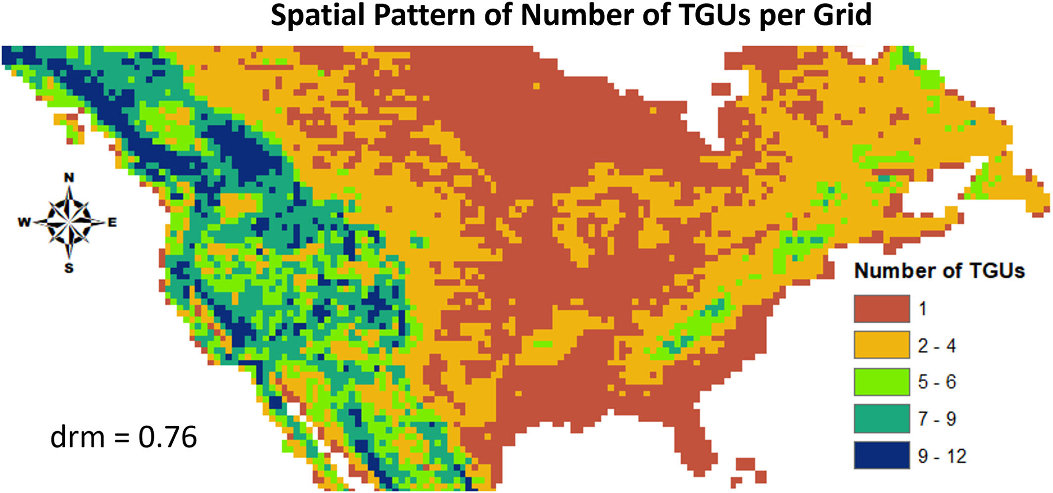
 per half degree grid showing the capability of the topography-based subgrid structure to capture topographic heterogeneity over mountainous areas and the associated data reduction metric (drm) which is a measure of the computational efficiency of defining a variable number of TGUs per grid relative to assigning the maximum number of TGUs per grid, which is 12 in this study. Credit: Journal of Advances in Modeling Earth Systems (2024). DOI: 10.1029/2023MS004064")
Earth system models (ESMs), used in climate simulations and projections, typically use grids of 50–200 km resolution. These are considered relatively coarse with limited ability to resolve land surface variability.
To enhance the capability of ESMs to simulate the impacts of small-scale land surface differences, a new study introduces a new subgrid structure. Researchers also used methods to downscale atmospheric variables, such as precipitation and temperature, from the atmosphere grid to subgrid topographic units established in their earlier studies for the Energy Exascale Earth System Model (E3SM) Land Model (ELM).
The work is published in the Journal of Advances in Modeling Earth Systems.
Analysis of ELM simulations with and without the new land surface subgrid and downscaled atmospheric variables revealed their significant impacts on snowfall, snow water equivalent, and runoff. These results were particularly evident in regions dominated by mountainous landscapes and where maximum precipitation occurred during the cool seasons.
The new developments noticeably enhance the capability of ELM to reproduce measured observations for snow water equivalent (i.e., the amount of liquid water held in snow) at the Snow Telemetry (SNOTEL) sites in the western United States.
By improving the capability of ELM to reproduce the observed snow water equivalent at 83% of the SNOTEL sites across the western United States, this study motivates the incorporation of the new model features in E3SM for understanding the regional and global water cycles and their future changes. This can in turn provide the basis for more effective water management plans and action.
Effects of the new developments on simulations of land surface processes were evaluated using the conterminous (i.e., contiguous) United States (CONUS) as a case study. ELM simulations with the new developments generally yielded higher amounts of snowfall, snow water equivalent, and runoff over CONUS. Effects of the new developments were found to be greater over regions dominated by higher-elevation landscapes and regions with maximum precipitation during cool seasons.
The new developments also improved ELM’s ability to reproduce observed snow water equivalent at the SNOTEL sites, contributing to the overall enhancement of the prediction accuracy of the model. The results of this study have important implications for modeling streamflow and water resources management, both of which are strongly influenced by hydrologic processes in mountainous regions.
More information:
Teklu K. Tesfa et al, Impacts of Topography‐Based Subgrid Scheme and Downscaling of Atmospheric Forcing on Modeling Land Surface Processes in the Conterminous US, Journal of Advances in Modeling Earth Systems (2024). DOI: 10.1029/2023MS004064
Provided by
Pacific Northwest National Laboratory
Citation:
Capturing finer-scale topographic differences improves Earth system model capability to reproduce observations (2024, October 4)
retrieved 4 October 2024
from https://phys.org/news/2024-10-capturing-finer-scale-topographic-differences.html
This document is subject to copyright. Apart from any fair dealing for the purpose of private study or research, no
part may be reproduced without the written permission. The content is provided for information purposes only.