
Mount Everest has grown an additional 15 to 50 meters due to the erosive forces of the Arun River.
This erosion triggers isostatic rebound—a process where the Earth’s crust rises due to reduced surface mass, causing Everest to rise approximately 2 millimeters annually.
Uplift Mechanisms of Mount Everest
Mount Everest is about 15 to 50 meters (50 to 165 feet) taller than it would otherwise be because of uplift caused by a nearby eroding river gorge, and continues to grow because of it, finds a new study by UCL researchers.
The study, published in Nature Geoscience, found that erosion from a river network about 75 kilometers (~50 miles) from Mount Everest is carving away a substantial gorge. The loss of this landmass is causing the mountain to spring upwards by as much as 2 millimeters a year and has already increased its height by between 15 and 50 meters over the past 89,000 years.
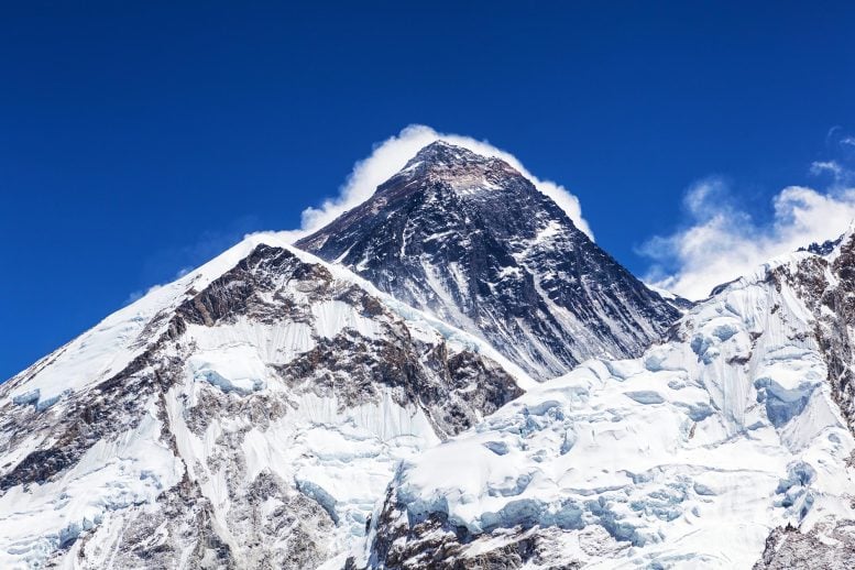
Everest’s Anomalous Elevation
At 8,849 meters high, Mount Everest, also known as Chomolungma in Tibetan or Sagarmāthā in Nepali, is the tallest mountain on Earth, and rises about 250 meters above the next tallest peak in the Himalayas. Everest is considered anomalously high for the mountain range, as the next three tallest peaks – K2, Kangchenjunga, and Lhotse – all only differ by about 120 meters from each other.
A significant portion of this anomaly can be explained by an uplifting force caused by pressure from below Earth’s crust after a nearby river eroded away a sizeable amount of rocks and soils. It’s an effect called isostatic rebound, where a section of the Earth’s crust that loses mass flexes and “floats” upwards because the intense pressure of the liquid mantle below is greater than the downward force of gravity after the loss of mass. It’s a gradual process, usually only a few millimeters a year, but over geological timeframes can make a significant difference to the Earth’s surface.
Mount Everest’s Ongoing Growth
The researchers found that because of this process, Mount Everest grew by about 15 to 50 meters over the last 89,000 years, since the nearby Arun river merged with the adjacent Kosi River network.
Co-author, PhD student Adam Smith (UCL Earth Sciences) said: “Mount Everest is a remarkable mountain of myth and legend and it’s still growing. Our research shows that as the nearby river system cuts deeper, the loss of material is causing the mountain to spring further upwards.”
Today, the Arun River runs to the east of Mount Everest and merges downstream with the larger Kosi River system. Over millennia, the Arun has carved out a substantial gorge along its banks, washing away billions of tonnes of earth and sediment.
Co-author Dr. Jin-Gen Dai of the China University of Geosciences, said: “An interesting river system exists in the Everest region. The upstream Arun River flows east at high altitude with a flat valley. It then abruptly turns south as the Kosi River, dropping in elevation and becoming steeper. This unique topography, indicative of an unsteady state, likely relates to Everest’s extreme height.”
Regional Impact Beyond Everest
The uplift is not limited to Mount Everest, and affects neighboring peaks including Lhotse and Makalu, the world’s fourth and fifth highest peaks respectively. The isostatic rebound boosts the heights of these peaks by a similar amount as it does Everest, though Makalu, located closest to the Arun River, would experience a slightly higher rate of uplift.
Co-author Dr. Matthew Fox (UCL Earth Sciences) said: “Mount Everest and its neighboring peaks are growing because the isostatic rebound is raising them up faster than erosion is wearing them down. We can see them growing by about two millimeters a year using GPS instruments and now we have a better understanding of what’s driving it.”
Insights Into Himalayan Uplift Dynamics
By looking at the erosion rates of the Arun, the Kosi, and other rivers in the region, the researchers were able to determine that about 89,000 years ago the Arun river joined and merged with the Kosi River network, a process called drainage piracy. In doing so, more water was funneled through the Kosi River, increasing its erosive power and taking more of the landscape’s soils and sediments with it. With more of the land washed away, it triggered an increased rate of uplift, pushing the mountains’ peaks higher and higher.
Lead author Dr. Xu Han of China University of Geosciences, who carried out the work while on a China Scholarship Council research visit to UCL, said: “The changing height of Mount Everest really highlights the dynamic nature of the Earth’s surface. The interaction between the erosion of the Arun river and the upward pressure of the Earth’s mantle gives Mount Everest a boost, pushing it up higher than it would otherwise be.”
Reference: “Recent uplift of Chomolungma enhanced by river drainage piracy” 30 September 2024, Nature Geoscience.
DOI: 10.1038/s41561-024-01535-w