
The Copernicus Sentinel-2 mission captured a detailed image of the Burning Man festival in the Black Rock Desert, Nevada, showing over 70,000 attendees and their temporary art installations.
This image, taken by the newly launched Sentinel-2C satellite, showcases the festival’s unique setting in the Great Basin Desert and the stunning white sands of its location.
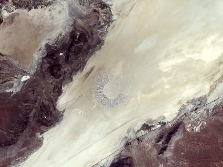
Capturing Burning Man From Space
The Copernicus Sentinel-2 mission has snapped a souvenir of the Burning Man festival in the Black Rock desert in Nevada.
Covering about 2600 sq km (~1000 sq miles), the Black Rock Desert is an arid region of lava beds and alkali flats in northwestern Nevada. The picture, acquired on August 26, 2024, captures the white, sandy area in the southwestern part of the desert, where the Burning Man festival takes place annually.
Over 70,000 people gathered from August 25 to September 2 at Black Rock for the desert-based event. This image, taken from orbit on the second day of the event, shows the area of camper vans and tents grouped together for the week-long art and self-expression festival, which involves music, stunning art installations, experimental and interactive sculptures, and art cars, among others.
The name comes from its culminating ceremony, featuring the symbolic burning of a large wooden effigy, referred to as the Man, located at the dead center of this temporary settlement.
Geographic and Environmental Context
Like most of Nevada, the Black Rock Desert lies within the Great Basin Desert, the largest in the US, covering an arid expanse of some 492,000 sq km (190,000 sq miles). The Great Basin is noted for its internal drainage system, in which precipitation never reaches an outlet to the sea.
Stretching and uplifting of Earth’s crust over the past 17 million years have resulted in a recurrent pattern of valleys and rugged north-south mountain ranges, like those visible in brown around the sandy area.
Advancements in Earth Observation
The Copernicus Sentinel-2 mission is based on a constellation of two identical satellites flying in the same orbit but 180° apart, to cover all of Earth’s land and coastal waters every five days.
On September 5, 2024, the third satellite in the mission, Sentinel-2C, was launched into orbit to join its siblings and ensure the continuous provision of high-resolution data from the mission.
Less than two weeks after launch, Sentinel-2C has delivered its stunning first images, proving that the satellite is not only working as expected, but has already surpassed expectations.