
Just days after its launch, Sentinel-2C is already providing stunning Earth imagery, capturing everything from urban landscapes to natural disasters. Its high-resolution multispectral imager enhances our ability to monitor and manage environmental and urban dynamics, paving the way for future advancements with the Sentinel-2 Next Generation.
Less than two weeks after being launched into orbit, Sentinel-2C has delivered its first images. These spectacular views of Earth offer a sneak peek at the data that this new satellite will provide for Copernicus – Europe’s world-leading Earth observation program.
The third Copernicus Sentinel-2 satellite was launched from Europe’s Spaceport in French Guiana aboard the final Vega rocket on September 5 at 03:50 CEST (September 4 at 22:50 local time).
Advanced Imaging Capabilities
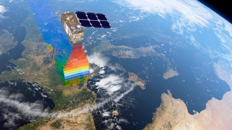
Like its siblings, Sentinel-2A and Sentinel-2B, the satellite carries a multispectral imager that takes high-resolution images of Earth’s land, islands, and inland and coastal waters from its orbital altitude of 786 km (477 miles).
With a large swath width of 290 km (180 miles), it provides continuous imagery in 13 spectral bands with resolutions of 10 m (33 feet), 20 m (66 feet), and 60 m (197 feet).
Global Coverage and Initial Insights
Just a week after launch, Sentinel-2C acquired a rich initial set of images across the globe, which were processed by the Copernicus Ground Segment.
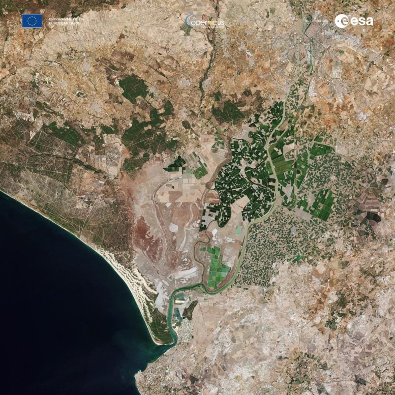
One of the first images features a clear view of Seville and surroundings in southern Spain. Seville, the capital of Andalusia, lies on the Guadalquivir River, one of the longest rivers in Spain. Seville holds the Presidency of the Ariane 2024 Community of Cities, and is home to the headquarters of the Spanish Space Agency.
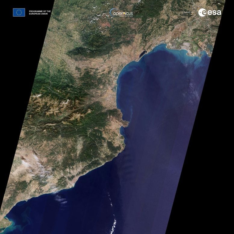
Thanks to the satellite’s impressive 290-km-wide swath, another image offers a long strip that stretches from Camargue and Montpellier in southern France all the way down to south of Barcelona in Spain.
Highlighting Natural and Human-Made Phenomena
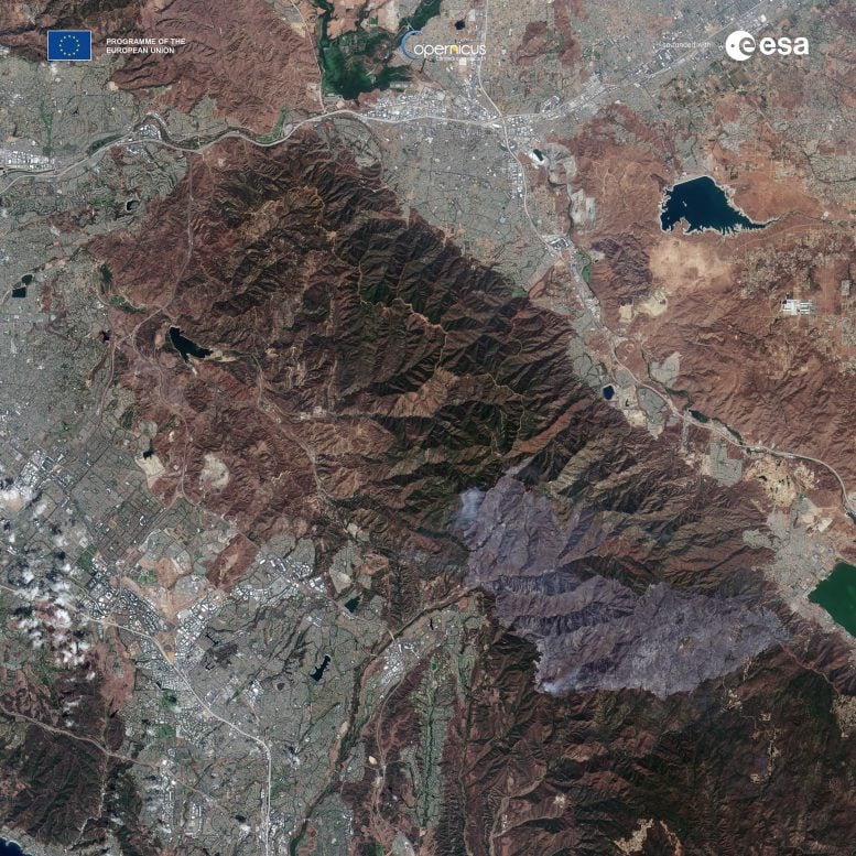
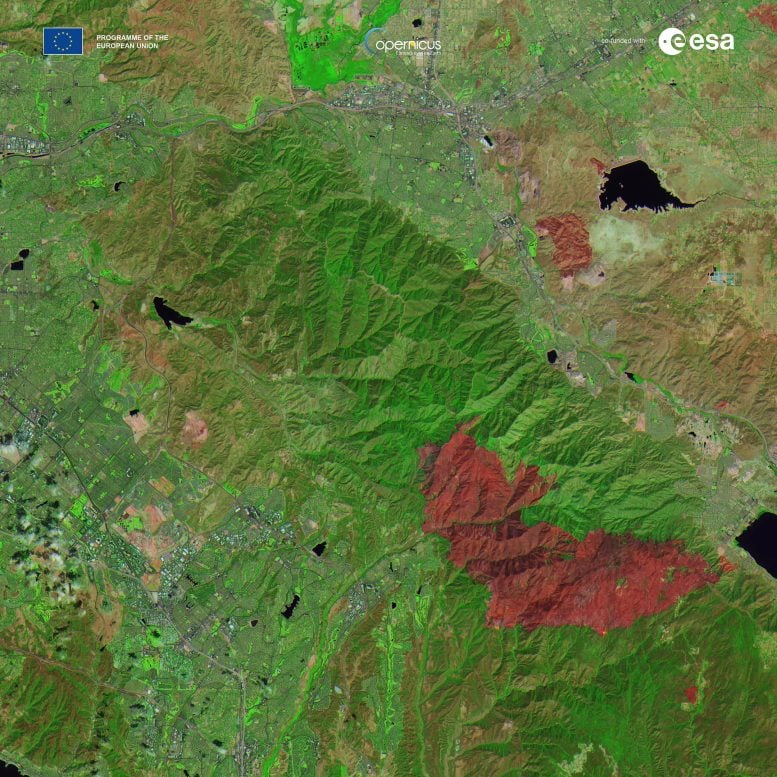
Sentinel-2C also observed an area of south of Los Angeles, California. Here, the image, acquired on September 12, has been processed using the multispectral imager’s different bands to highlight one of the wildfires that the state is currently battling.
The natural color image on the left captures smoke billowing from the Airport Fire while the false-color image on the right has been processed using the instrument’s shortwave infrared and near-infrared channels to show the large area that has been burned and the active fires, which can be seen as bright orange spots.
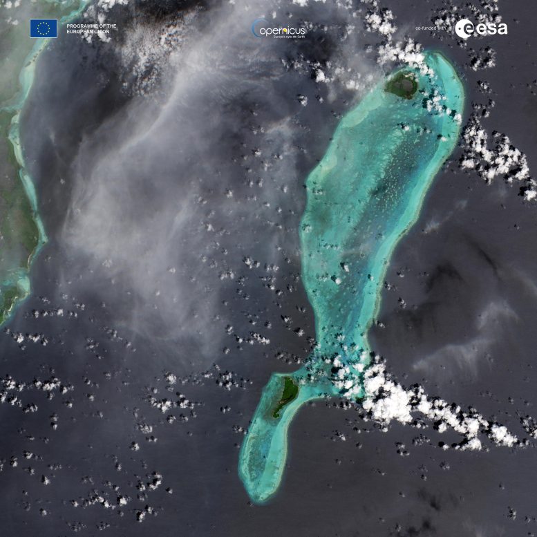
On a more serene note, another image features Lighthouse Reef, part of the large coral reef system off the coast of Belize in Central America. Here the famous Great Blue Hole can be seen – a giant marine sinkhole.
ESA’s Director of Earth Observation Programmes, Simonetta Cheli, said, “These initial images stand as a powerful testament to the success of this extraordinary mission. While Sentinel-2 will continue to serve Copernicus with distinction for years to come, we are already looking ahead as we develop the next chapter with the Sentinel-2 Next Generation mission.”
Calibration and Ongoing Operations
Following the completion of Sentinel-2C’s launch and early orbit phase, with the satellite working as expected, the multispectral imager will spend the next three months being calibrated as part of the commissioning phase.
Sentinel-2C commissioning activities are carried out in parallel with the routine operations of Sentinel-1, Sentinel-2, Sentinel-3 for land, and Sentinel-5P.
Exceptional Performance and Data Utility
Despite being early in its mission, the quality of these first images has already surpassed expectations.
Constantin Mavrocordatos, Sentinel-2 Project Manager at ESA, remarked, “We are thrilled to see the Copernicus Sentinel-2C already capturing such breathtaking images of Earth so soon after its launch. This is just the beginning of the incredible insights and detailed data it will provide, helping us better understand our planet.”
Francisco Reina, Sentinel-2 Payload Manager, added, “It is truly remarkable how well the multispectral instrument had been calibrated even before the satellite was launched, producing such stunning first images. This achievement is the result of an outstanding collaboration between ESA and the Airbus teams throughout the instrument’s development phase.”
Broad Applications and Data Accessibility
Copernicus Sentinel-2 data are used for a broad range of applications, including agriculture, water quality monitoring, natural disaster management, including wildfires, volcanic eruptions, and floods.
As for all Copernicus missions operated by ESA, Sentinel-2 data are freely available via the Copernicus Data Space Ecosystem. Data from the new ‘C’ satellite will be accessible to users once the satellite is fully commissioned.
The Sentinel-2 mission is part of Copernicus – the Earth observation component of the European Union’s Space program.