. DOI: 10.1016/j.rse.2024.114380")
The Congo Basin rainforest is the second-largest tropical forest in the world, storing large volumes of carbon and hosting high levels of biodiversity. While these forests have historically stayed mostly intact, road development has recently become a critical threat.
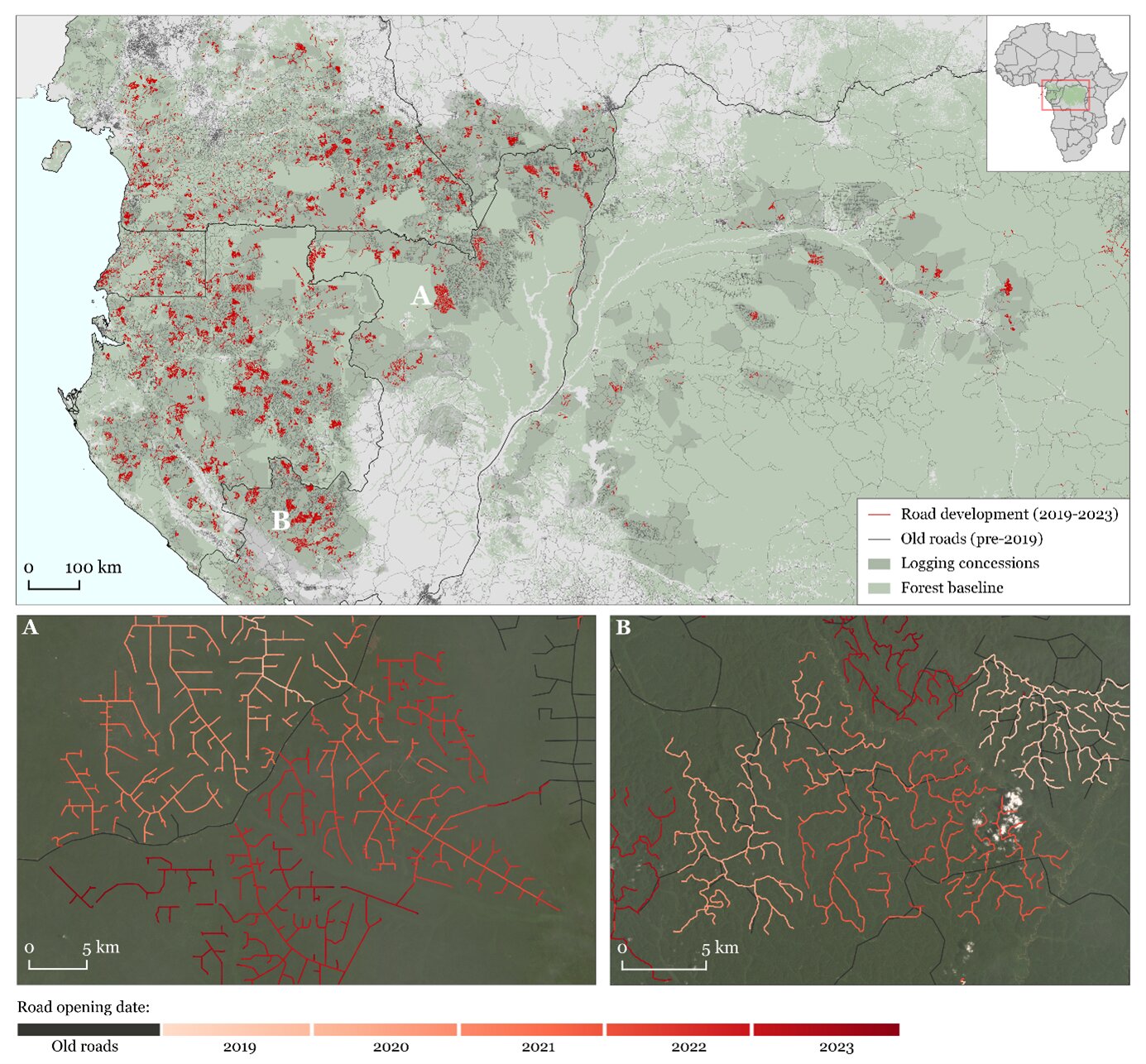
A new study has used satellite images and artificial intelligence to map Congo Basin forest roads in unprecedented detail. This provides crucial new information for forest conservation and management.
Most of the road networks in the Congo Basin are built to facilitate industrial selective logging: the harvesting of mature and valuable timber while leaving the majority of forest intact. This can be a relatively sustainable practice that significantly benefits the regional economies.
But the opening of temporary roads to facilitate forest access also leads to large carbon emissions and has long-lasting impacts on forest ecosystems. Another negative side-effect is that roads open up remote forest regions, which may lead to illegal hunting, mining and agricultural development.
Advanced detection method making every road visible
Timely and transparent information on where and when road networks are being built is of critical importance for sustainable logging practices and forest and biodiversity conservation. Current forest road maps are seriously incomplete or outdated, because they rely on labor-intensive manual digitization of satellite images.
Researchers have now developed an automated method to detect forest roads from satellite images. Their study was recently published in Remote Sensing of Environment. It demonstrates an advanced detection method based on deep learning techniques and a combination of high-resolution optical and radar satellite images.
Bart Slagter, Ph.D. researcher at Wageningen University & Research and lead author of the study said, “The optical sensors provide detailed imagery during clear weather conditions, while the radar sensors can ‘see through’ clouds during persistent rainy seasons in the tropics. In this way, even the most narrow and transient road segments can be precisely located.”
The algorithm processed and analyzed hundreds of thousands of satellite images in a cloud-based processing platform Google Earth Engine.
“We mapped almost 50,000 km of road development in the Congo Basin during the last five years,” Slagter explained. “This inventory will be continuously updated for the years to come. We are also aiming to apply these methods to the Amazon and Southeast Asian rainforests.”
The Congo Basin forest road map reveals some striking trends. Countries in the western part of the region (Cameroon, Equatorial Guinea, Gabon, Republic of Congo) showed large amounts of road development in recent years, a result from the extensive logging activities permitted in these countries. Furthermore, almost a quarter of the Congo Basin forest roads opened up intact forests that had no signs of previous human influence.
Towards logging with minimal environmental damage
Elaborating further on the significance of this study, senior co-author Kurt Fesenmyer—a forest spatial data scientist with The Nature Conservancy—explained, “The integration of this satellite monitoring system into forest management practices provides a crucial step forward in balancing profitable logging operations with minimal environmental damage.
“This may include promoting Reduced Impact Logging for Climate (RILC) practices such as improved road design, preventing the expansion of roads into protected areas, and ensuring that abandoned roads are properly closed to avoid further human influence in remote forests.”
Furthermore, the continuously updated road maps are of critical importance to formulate forest conservation strategies at a large scale, as roads are strong indicators of human influence on natural systems. The detailed and up-to-date road maps can substantially improve popular conservation metrics like “human footprints” or “intact forest landscapes,” and enable governments and NGOs to better protect critical areas from deforestation and forest degradation.
More information:
Bart Slagter et al, Monitoring road development in Congo Basin forests with multi-sensor satellite imagery and deep learning, Remote Sensing of Environment (2024). DOI: 10.1016/j.rse.2024.114380
Provided by
Wageningen University
Citation:
Road networks stretch into Congo Basin forests: Satellites and AI help to monitor (2024, September 16)
retrieved 16 September 2024
from https://phys.org/news/2024-09-road-networks-congo-basin-forests.html
This document is subject to copyright. Apart from any fair dealing for the purpose of private study or research, no
part may be reproduced without the written permission. The content is provided for information purposes only.